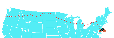
| CTN TransAm 09 40 days on the road 3750 miles by bicycle |
 |
Chris Nadovich's 2009 Transamerica Bike Tour.
Contact Me
Sat, 13 Jun 2009
A couple hours after rolling out of Lincoln, MT, we crossed the Continental Divide at Rogers Pass on Montanna Route 200. This pass was even easier than Lolo; Gary and I shook our heads when we saw that the slight grade was coming to an end at a gap between two apparantly (from our view) small peaks. That's it. The dreaded Rocky Mountains are behind us.
It's downhill from here.
Rogers would be a lot more difficult westbound as the pass drops immediately to the plains of central Montanna. Westbound riders see an endlessly wide and impossibly high wall of mountain. Riders would have a steep grade for several miles. Coming from Lincoln, however, we saw nothing of the sort. The west side of the pass is filled in with a high plateau. It's striking to see 5000-6000 foot peaks poking just a few hundred feet above the flat plain that, itself, is at near 5000 feet -- like tips of icebergs.
At the divide I conducted an experiment that I believe many before me have also tried. I deposited some "fluid" exactly on the divide and attempted to discern what direction it would flow. Results were not conclusive.
We are closing in on our first 1000 miles, which is about a quarter of the way, but psychologically it feels more like a third. The Rocky Mountains: been there, done that. Now, the new challenge is the vast nothingness of the Great Plains and the wind they call Moriah.


